Topographic
Advertisement
Jisio Network Designer v.1.0
The goal is to get a logic and a topographic view on the network. The prototype Jisio (OBST Network Visualization based on platform independent Java) can collect GPS-data to generate a map of your network area.
Advertisement
Earth Explorer v.6 1
Earth Explorer is a useful application very similar to Goggle Earth that allows you explore the whole world. It provides satellite, topographic, and blend views of any part of the world.
MT Topo - Public Lands v.2 1
This mapset contains topographic, hydro, road, trail, POI, and public land data for the state of Montana. Topo lines dissipate quicker as zoom scale increases. Much improved over the Garmin 24K series when zoomed out.
TerraViewer v.1.1
TerraViewer makes use of Microsofts free TerraService web service to retrieve and display archived satellite images and topographic maps of any region in the United States. You can search for regions by long/lat values or by city names.

MoreMaps v.1.1.0.0
Enjoy all the beatiful maps from the Norwegian Mapping Authority. All the way from N-series maps through topographic maps and sea maps. There's even a simple tracking capability that will pinpoint your geographical position, including speed and
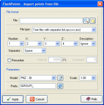
FlashPoints for AutoCAD and BricsCAD v.2.0
FlashPoints is a tool for creating and managing points Groups (topographic points for example).
TOPOWIN English v.13.00
TOPOWIN is a state-wide register of the German topographic cartographies and of localities with geo references in different coordinate systems. It also is a topographic information system.
Mapster v.1.1
Mapster is a program for creating custom topographic maps of arbitrary size for printing.
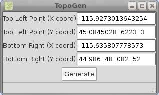
TopoGen v.0.2
TopoGen is a small PyGTK application which will make a topographic image overlay for Google Earth using the given coordinate boundaries.
WW2D v.1.0
WW2D allows you to explore Earth using satellite imagery, topographic maps and image from other data sources also providing large placenames and boundaries database and allowing you to install community-made add-ons for even more info about our plane
Topos US v.1.1
Topos US is an app that provides access to download and view high resolution USGS topographic maps for the United States.